|
"Built almost
entirely with a labor force of over 1,000 slaves in July, 1864, the River
Line was a series
of connected Civil War fortifications intended to stop Sherman's attack on
Atlanta..."
Seventy odd years before the French even
dreamed of the Maginot Line, an equally impregnable version of that famous
defensive fortification was built in Cobb County. Both met the same fate -
out-flanked by the enemy.
Built almost entirely with a labor force of over 1,000 slaves in July,
1864, the River Line was a series of connected Civil War fortifications
intended to stop Sherman's attack on Atlanta.
The line was six miles long, extending from just south of Veterans
Memorial Highway (Bankhead Highway) into the community of Vinings. The
northern terminus of the fortifications was located at a point off Polo
Lane near the river, where a large artillery fort was constructed. The
line crossed Woodland Brook Drive near Polo Lane, Rebel Valley View,
Settlement Road, and the CSX Railroad (then Western & Atlantic), the line
of fortifications crossed Atlanta Road south of I-285. Then turning in a
more southernly direction, the line extended through Oakdale, and followed
the ridge on which Oakdale Road is located to a point south of Veterans
Memorial Highway, near Nickajack Creek.
In June and July of 1864, armies of the United States under Major General
William T. Sherman attacked Confederate fortifications on Kennesaw
Mountain. Confederate forces repulsed them in one of the bloodiest battles
of the war. Seeing the futility of continuing to attack a strongly
fortified line, the federals resorted to a flanking movement, the same
tactic which had pushed Joseph E. Johston's Confederate army of Tennessee
back steadily from Dalton to the outskirts of Atlanta.
Enjoying distinct superiority of numbers and equipment, Sherman
successfully used the tactic of confronting the Confederates with a
sizable force, while other units of his army moved around the side, or
flank of the rebel forces. In order to avoid an attack into their side and
rear, the southern forces would fall back and form a new line of defense.
After the Battle of Kennesaw Mountain, this flanking movement began. Not
wanting to allow the federal forces to get between him and Atlanta,
Johnston once again withdrew, abandoning Kennesaw Mountain and its line of
fortifications.
On Johnston's staff was a brilliant officer with a variety of experience,
Brigadier General Francis Ashbury Shoup. In an effort to stop the pattern
of retreating, and to stop the federals short of Atlanta, Shoup conceived
the plan for a string of impregnable fortifications backing up to the
Chattahoochee River. He presented his plan to Johnston, and the plan was
approved in time to complete the fortifications before the rebel forces
fell back from Kennesaw through Marietta and Smyrna.
Shoup had spent a part of his life prior to the war in St. Augustine,
Florida, where he doubtlessly was inspired by the imposing Castillo de San
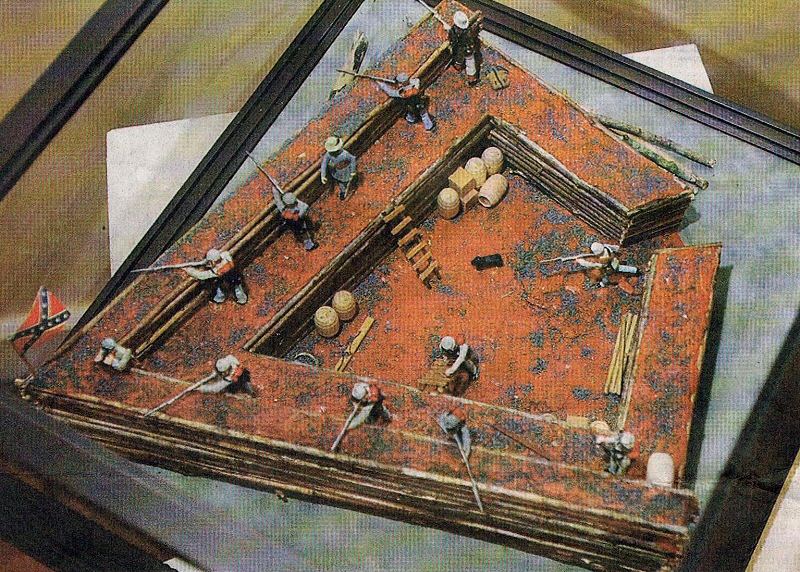
Margos. This old Spanish fort is a classic example of the use of bastions,
small arrowhead-shaped forts which protrude out from its corners. Gunners
in the bastions could fire into the sides and backs of enemies who may be
attacking another part of the walls. Likewise, fire from the walls would
protect the bastions. A graduate of West Point, Shoup was also well
educated in the design and use of military fortifications.
The Chattahoochee river line, sometimes called Johnston's River line,
consisted of 36 of these arrowhead-shaped forts, connected by a strong
wall of log palisades and trenches. The forts are commonly called "Shoupades"after
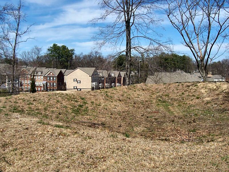
their designer, Gen. Shoup. Most of them were graded away as Vinings and
Oakdale developed, but a few still remain.
The most accessible, and the one most likely to be preserved, is near the
southern end of the line, and is on land now owned by Cobb County. Another
is on Oakdale Road, partly in an apartment complex, and partly in the yard
of a residence. One is off Atlanta Road in John Weilands's "Olde Ivy"
development. A few scattered Shoupades are in the yards of homeowners and
on church grounds.
Did the Chattahoochee River Line perform the task for which it was
designed and laboriously constructed? Obviously not, or the national
capital might be in Richmond today.
Confederate forces briefly occupied the River Line after their withdrawal
from Smyrna and Marietta. When federal forces, in hot pursuit, encountered
the line, bristling with cannons and Shoupades, they wisely decided not to
waste lives by throwing men against such an impregnable obstacle. Sherman
resorted to the same old tactic which had brought him from Dalton to the
edge of Atlanta, a flanking movement.
As soon as General Johnston heard that Sherman's troops has crossed the
Chattahoochee River above and below his fortress, he had his Confederate
army abandon the River Line and withdrew into fortifications around
Atlanta.
Just as German forces negated the power of the Maginot line by going
around it, so did the United States forces negate the effectiveness of the
Chattahoochee River Line.
Historians William R. Scaife and William E. Erquitt wrote a book on the
line in 1992, entitled the Chattahoochee River Line. The book contains
much more information, including photographs of model Shoupades, details
of construction, maps of the line and of troop movements, and more details
about the Civil War in Cobb County.
Originally published in April-May 2001
edition of Living Magazine by Marion Blackwell, reproduced with the
author's permission. |